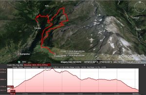
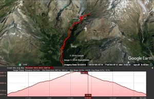
FRACHEY – TACONET – LAGO CIARCERIO – CREST -CUNEAZ – FRACHEY
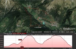
LEVEL: INTERMEDIATE DISTANCE: 18 km D+ : 1178 mt INFO: Gravel road along the winter slopes. 2 Peacks and 3 lakes along the road. 3
LEVEL: INTERMEDIATE DISTANCE: 18 km D+ : 1178 mt INFO: Gravel road along the winter slopes. 2 Peacks and 3 lakes along the road. 3
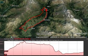
Frachey Ru Courtaud Barmasc LEVEL: INTERMEDIATE DISTANCE: 21,8 km D+: 1028 mt INFO: Bike map for an easy and panoramic tour in Ayas. Good for

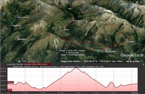
LEVEL: EASY DISTANCE: 10,8 km each way D+ : 1041 mt INFO: Gravel road ending on a smaller path. Suitable to all levels. Visit the
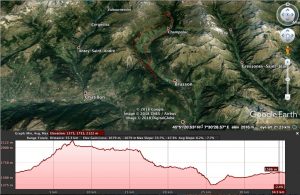
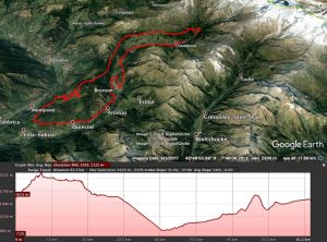
LEVEL: INTERMEDIATE DISTANCE: 55,1 km D+: 2425 mt INFO: Mixed single tracks and a bit of gravel roads. Quick and fun way down to Extrepieraz,
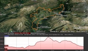
LEVEL: INTERMEDIATEDISTANCE: 35,3 kmD+: 1679 mtINFO: Easy and panoramic tour around Val d’Ayas. First part easy. Second part medium level with 15 mins of walk
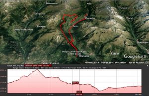
LEVEL: INTERMEDIATE DISTANCE: 16,5 km D+: 863 mt INFO: Nice and easy gravel road up to Pian di Verra. A bit harder part after that

LEVEL: DIFFICULTDISTANCE: 89,9 kmD+ : 4202 mtINFO: Visit Monterosa Prestige for info and pictures!
LEVEL: INTERMEDIATEDISTANCE: 32,7 kmD+: 1594 mtINFO: Mixed single tracks and gravel roads with lots of beautiful seightseeing spots.Different restaurants and bars along the road. Check

LEVEL: INTERMEDIATEDISTANCE: 48,5 kmD+: 2545 mtINFO: Check out Monterosa Prestige for info and pictures!
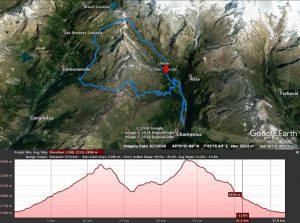
LEVEL: INTERMEDIATEDISTANCE: 61,2 kmD+: 2433 mtINFO: Long tour passing along the old Courtod channel built in 1393. A pearl parcour rich of pines forest and
LEVEL: INTERMEDIATEDISTANCE: 30,8 kmD+: 1586 mtINFO: From Antagnod reach Barmasc and continue up to meet the Ru (channel). Pass a bridge and continue for about
LEVEL: INTERMEDIATE DISTANCE: 14,1 km D+: 954 mt INFO: Fun round starting from Brusson up to Extrepieraz up to Col de Joux and down a

LEVEL: INTERMEDIATEDISTANCE: 14,4 kmD+: 1132 mtINFO: Start with the orange line and take the green line on the way down.Steep stairs part between the two
LEVEL: DIFFICULT DISTANCE: 37 km D+: 2396 mt INFO: Extreme tour bringing you up to Rifugio Tournalin, from there you will need to carry your