Tournalin – Cime Bianche

LEVEL: DIFFICULT DISTANCE: 37 km D+: 2396 mt INFO: Extreme tour bringing you up to Rifugio Tournalin, from there you will need to carry your bike for about 1 km to the top on a pretty steep path. After that great fun all the way down to Cheneil. A traverse starts from there heading to […]
Frachey – Colle Bettaforca – Resy – Frachey

LEVEL: INTERMEDIATEDISTANCE: 14,4 kmD+: 1132 mtINFO: Start with the orange line and take the green line on the way down.Steep stairs part between the two yellow marks. INGRANDISCI LA MAPPA
Brusson – Salomon – Extrepieraz – Col De Joux

LEVEL: INTERMEDIATE DISTANCE: 14,1 km D+: 954 mt INFO: Fun round starting from Brusson up to Extrepieraz up to Col de Joux and down a bit more technical single track! Enjoy! INGRANDISCI LA MAPPA
Antagnod – Pian Pera – Barmasc + Tunnels – Col De Joux – Extrepieraz – Pracharbon – Periasc – Champoluc

LEVEL: INTERMEDIATEDISTANCE: 30,8 kmD+: 1586 mtINFO: From Antagnod reach Barmasc and continue up to meet the Ru (channel). Pass a bridge and continue for about 10 mins. Walk your bike for 15 min down a path and start 14 tunnels (YOU WILL NEED A TORCH). Continue till the end of the tunnels and start a […]
Big Tour Val d’Ayas

LEVEL: INTERMEDIATEDISTANCE: 61,2 kmD+: 2433 mtINFO: Long tour passing along the old Courtod channel built in 1393. A pearl parcour rich of pines forest and magic views. You will pass in 16 tunnels so torch will be needed! Continuing on the other side of the valley you will have a great view of all Aosta […]
MONTEROSA CLASSIC TOUR

LEVEL: INTERMEDIATEDISTANCE: 48,5 kmD+: 2545 mtINFO: Check out Monterosa Prestige for info and pictures! INGRANDISCI LA MAPPA
MONTEROSA ADVENTURE

LEVEL: INTERMEDIATEDISTANCE: 32,7 kmD+: 1594 mtINFO: Mixed single tracks and gravel roads with lots of beautiful seightseeing spots.Different restaurants and bars along the road. Check out Monterosa Prestige for info and pictures! INGRANDISCI LA MAPPA
Monterosa Extreme

LEVEL: DIFFICULTDISTANCE: 89,9 kmD+ : 4202 mtINFO: Visit Monterosa Prestige for info and pictures! INGRANDISCI LA MAPPA
FRACHEY – LAGO BLU
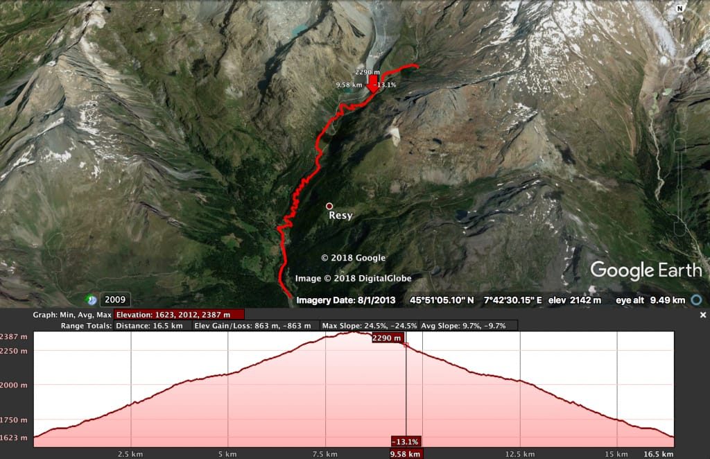
LEVEL: INTERMEDIATE DISTANCE: 16,5 km D+: 863 mt INFO: Nice and easy gravel road up to Pian di Verra. A bit harder part after that up to Pian di Verra Superiore. For the really enduro skilled biker nice trail down from Pian di Verra Superiore to Lago blu down to pian di verra inferiore INGRANDISCI […]
Champoluc – Frachey – Nana – Barmasc – Col de Joux – Extrepieraz – Periasc – Champoluc

LEVEL: INTERMEDIATEDISTANCE: 35,3 kmD+: 1679 mtINFO: Easy and panoramic tour around Val d’Ayas. First part easy. Second part medium level with 15 mins of walk to get to 14 tunnels. Good single track for any level in Extrepieraz. Steep way back to Periasc. Nice and friendly from Periasc to Champoluc. INGRANDISCI LA MAPPA